
The Montafon Hut Circuit
Julie Vural and Liesbeth Blom have both spent many years adventuring in the mountains in all seasons. They first teamed up as hiking partners in 2020 and prior to the trip described here have hiked together in England, France and Switzerland, on the Cleveland Way, the South West Coast Path, the Tour du Mont Blanc and in the Beaufortain region.
trip summary
11 walking days, plus one rest day, starting in Bartholomäberg and ending in Latschau, both around 1000m altitude and a short bus ride from Schruns
8 nights spent at or above 2000m
Total distance: 141km
Total ascent: 7500m
Highest point: Seelucke at 2744m
We booked all the huts in advance, as we preferred to stay in private rooms where available. We are members of the Austrian Alpine Club (Britannia section) so were entitled to good discounts on accommodation

We couldn’t resist dipping our toes in the icy waters of the lake immediately below the glacier snout
DECIDING WHERE TO HIKE
Liesbeth and I had such a blast last September on our hut-to-hut hike in the Mont Blanc region, that almost as soon as it ended we were talking about planning another trip in 2022. The sense of achievement we felt planning and hiking our own point-to-point trip in the high mountains, for eleven days with a full backpack, usually negotiating at least one big pass each day, appeared to be addictive. But where to go?
After lots of googling, we came across the Montafon Hüttenrunde (Hut Circuit) in western Austria. Seemingly little-known to English speakers (most information on the internet seems to be in German), it ticked all the boxes for us: hut-to-hut; long enough for a two-week break; plenty of challenging high-altitude walking and passes but no glacier crossings; various early exit options in case of poor weather or emergency; and last but not least, easy access by public transport - we were able to start and finish in the same place - the town of Schruns, easy to reach by train from Zurich airport. Another plus: most of the huts are run by the Austrian or German Alpine Clubs - efficiently run, reasonably priced, and best of all, spectacularly located.

Source: Montafon.at
The route looked likely tougher than last year, on some days at least - more kilometers, more altitude change - but we’d caught the bug, and were up for the challenge. We chose to start at the very end of August, to avoid summer busyness while snow is still unlikely.
What a magnificent route it turned out to be! It took us through the heart of the three very different mountain ranges that frame the Montafon Valley - the moody highland heaths and silent peaks of the Verwall, the sharp dark teeth and looming glaciers of the Silvretta, and the sheer white cliffs of the Rätikon.
THE VERVALL
Our approach to the Verwall involved climbing up to the Wörmser Hut in rain and cloud, setting the tone for that section. Cocooned in fog, our attention became focussed on the visible details - drops of rain on the grass stalks, black salamanders on the path basking in the dampness, squat bushes overloaded with huge bilberries, a ghostly row of cairns materialising on a ridge.

An Alpine Salamander on the path, on our climb up to the Wörmser Hut.

Mountain beauty on the micro-scale: savouring the rich colours and textures of bilberry bushes, lichen and moss.
The cloud lifted a little the next day, but lingered in the valley, a tantalising veil capriciously drifting up and down as we hiked the four passes and 22km of the ‘Wörmser Hohenweg’ (High Route) to the only accommodation on the route, the Neue Heilbronner Hut. Much of the Verwall is a protected nature reserve - no roads, no ski infrastructure, no buildings, and hikers in single figures. It’s a true alpine wilderness and the only way was forward. Hiking this section was a serious test of endurance for us, but we felt we’d breathed the untamed spirit of the mountains.

This beautiful lake, the Kessisee, was a welcome surprise at the top of a punishing climb near the end of the Wörmerser Höhenweg, our longest day.
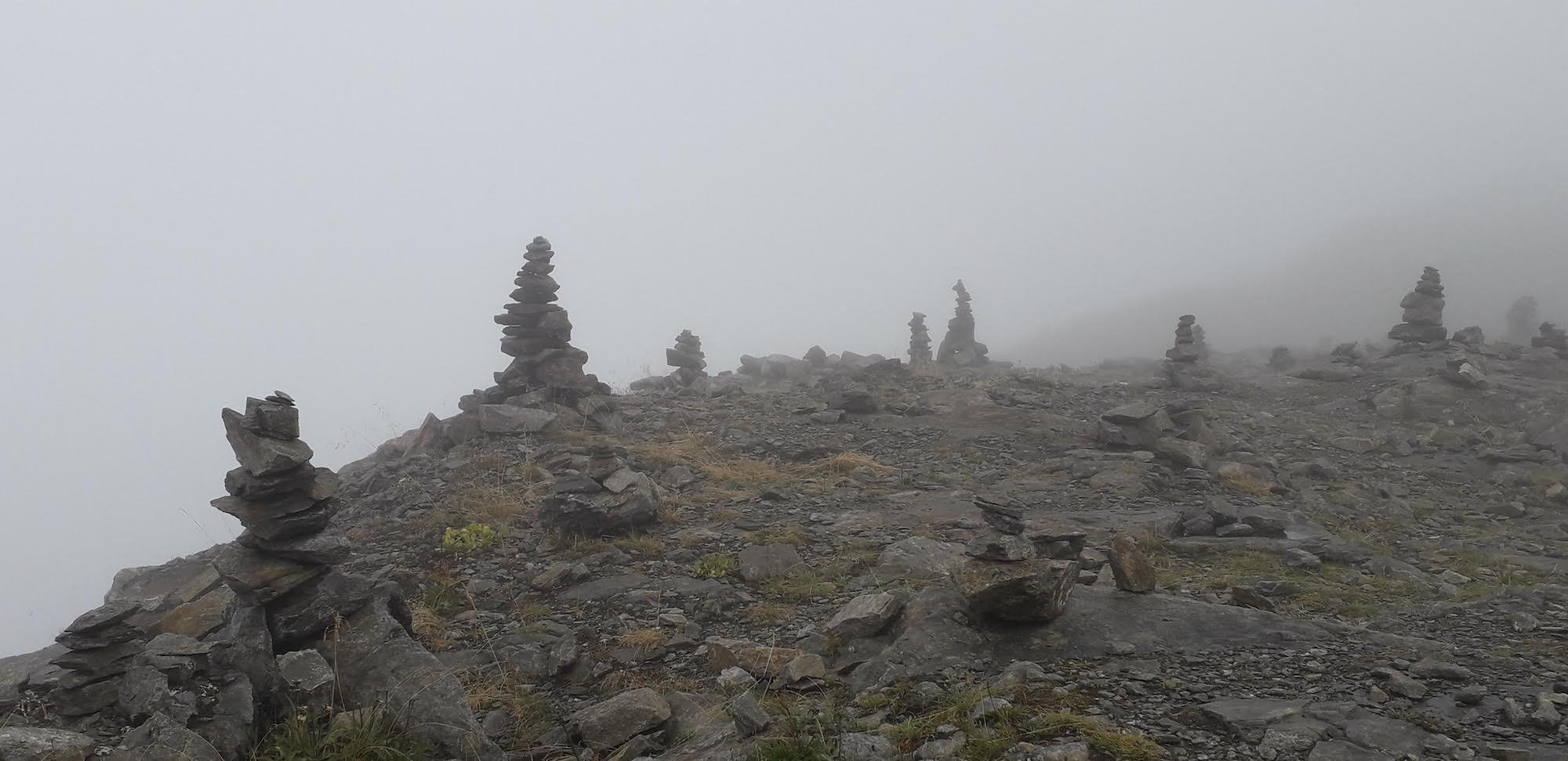
Ghostly cairns appearing through the mist on the ridge as we approached the Wörmser Hut
THE SILVRETTA
The Silvretta range announces itself boldly from the shores of the reservoir at the top of the Silvretta mountain road, where several glaciers and dark spiky peaks are on show to everyone, day-trippers, cyclists, bikers, hikers, and climbers alike. But only when we had left the road behind and hiked up to the isolated huts were we able to absorb the grandeur of this border region. The skyline from the terrace of the Wiesbadener Hut is dominated by brooding glaciers. The nearest one, the Ochsentaler, seemed almost close enough to touch, and it was only half an hour’s hike to the waterfall that feeds the milky meltwater pool beneath its snout. Above us loomed a mass of grey-white ice - tumbled, cracked, pinnacled, crouching atop a steep rocky cliff like an indolent monster surveying the valley below. We felt compelled to linger a while in this place of primal elements, dipping our feet in and out of the near-freezing water.

The Ochsentaler Glacier viewed from the Wiesbadener Hut
For the next two days we passed by glaciers, or above them, on almost every mountainside, as we made our way over high, moraine-strewn passes via the charming and welcoming Saarbrucker and Tübinger Huts. We were lucky to have dry weather with good visibility because parts of the trail here were rather sketchy - some sections were protected by cables but others needed surefooted concentration on large rocks or slithery glacial mud. ‘True Alpine Experiences’, we joked.

View of the See Glacier from the remote Plattenjoch, one of two passes over 2700m that we crossed between the Saarbrucker and Tübinger Huts.
This high terrain is wild and inhospitable, far from permanent human settlement, visited by relatively few, and the herds of ibex and chamois that we encountered near the tops of the highest passes seemed untroubled by our presence. Despite the desolation, they seem to thrive on the ridiculously sparse vegetation. But the glaciers are clearly shrinking. Some of those marked on our maps were all but invisible, smothered with rockfall scree. The effects of global warming were, sadly, all too visible - humankind’s reach is long.
We descended from the wild Silvretta via the long Vergaldatal, a protected and virtually pristine Alpine valley - a fitting farewell to this region. Halfway down, a pair of young marmots play-fighting and tumbling around the entrance to their colony, oblivious to observers, left us with a warm, fuzzy feeling before returning to civilisation in Gargellen village.
the Rätikon
We spent the last few days of our trip exploring the Rätikon range, easier to access from the main valley around Schruns and hence more visited by hikers. We felt a little saddened by the badly eroded state of some of the paths and the ugly lift infrastructure on the lower slopes, but we didn’t dwell on them - they were overwhelmingly trumped by the soaring cliffs of white limestone that formed the backdrop to the last days of our trip. We felt dwarfed by the monumental ‘pillars’ of the ‘Swiss Gate’ pass into Switzerland, where the swirling fog gave the impression of being on the edge of a precipice. And this range had its own ‘True Alpine Experience’ in store for us at the very end, just to remind us how pitiless the mountains can be. A vicious hailstorm and knife-like wind that blanketed the mountainside with ice sent us rummaging for the gloves, hats, and warm layers that had remained in the bottom of our packs until now.

The dramatic pillars of the Swiss Gate pass looking particularly atmospheric shortly before a vicious hailstorm.
THE VERDICT
We were blown away by the wild beauty of this route, an unforgettable immersion in the brooding, other-worldly presence of the mountains. And we’d faced and risen to the mountains’ challenges of terrain and weather, plus our personal challenges of endurance and motivation. The whole experience of hut-to-hut hiking in the high mountains, coming face to face with wilderness, is clearly addictive - we started thinking about options for our next trip even before finishing this one!
Author and photography: Julie Vural (Personal blog, Instagram, LinkedIn)
WHO ARE WE?
The Hiking Club empowers anyone to walk the way they want in the wild with personalised self-guided hiking experiences that are easy to find, quick to plan and simple to navigate.
We believe hiking experiences have the power to transform lives. With a growing range of personalised hikes that take into account your preferences, fitness and interests, we give you everything you need to explore the legendary trails of the world!