
As the days get longer and the weather starts to warm up in the Alps, I’m excited to share the draft plan I’ve come up with for my first adventure this hiking season. The 10 day journey through the Pennine Alps has been designed to spend time on the following trails we currently offer self-guided packages for (or shortly will!);
Hidden Paradise Tour (coming soon)
Tour des Combins (coming soon)
My proposed route comes in at just over 270 km / 169 mi with an intimidating 20,400 m / 67,000 ft of elevation gain...time to step up the training!
In this blog, I will share details about my;
Proposed Route
When planning a hike, I always start with a list of all the wonderful things I want to experience and then work out the plan I need to make it happen! For this hike, I want to;
See the best views of Mont Blanc;
Visit the symbolic birthplace of Saint Bernard dogs;
Stare across the Corbassière glacier at the Grand Combin peak;
Follow the glacier trail below the Mischebel mountain chain;
Traverse the Mattertal valley on the Europaweg trail; and
Finish at the mighty Matterhorn
The route I’m planning covers all of this and more while enjoying the mountain culture of the Swiss, French, and Italian Alps! See my daily breakdown below.
Day 1: Grand Balcon Sud along the Chamonix Valley
Day 1: Grand Balcon Sud on Hidden Paradise Tour and Tour du Mont Blanc
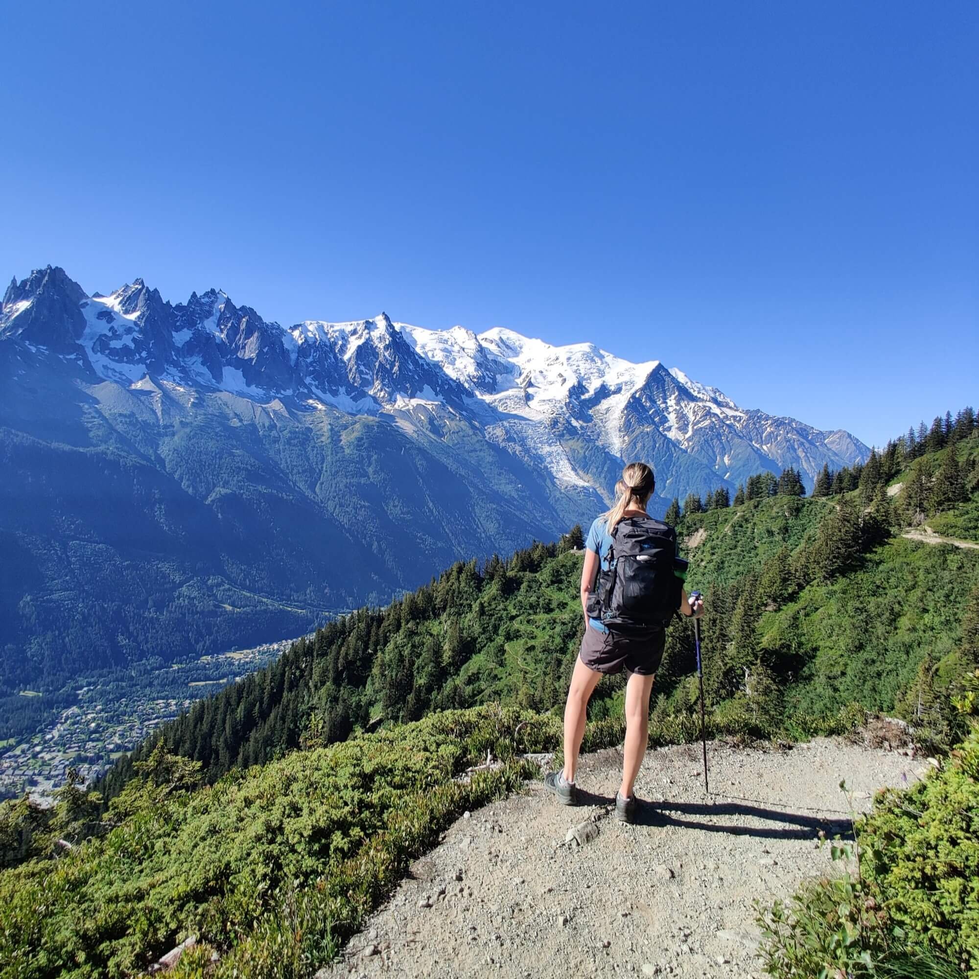
Route Summary: Arriving in the Chamonix valley just after lunch, I’ll head straight to Argentiere and hike a short distance to Tre-le-Champ to join the Tour du Mont Blanc trail. Following it counter clockwise, the trail first climbs up to Aiguillette d'Argentiére where a series of ladders then rapidly gains elevation to reach the Grand Balcon Sud. This trail is shared with the Hidden Paradise Tour and is typically regarded as the best section of both routes, with unparalleled views of the Mont Blanc summit and the glaciated massif surrounding it. I’ll follow the Grand Balcon Sud through La Flegere to Plan Praz, where the gondola down to Chamonix below won’t yet be running, requiring me to take the steep, almost 1,000m / 3,300 ft switchback descent to reach the valley below.
Hikes following this trail: Tour du Mont Blanc / Hidden Paradise Tour
Distance: 18.6 km / 11.6 mi
Elevation Gain: 1,419 m / 4,656 ft
Day 2: Vallorcine Loop via Emosson DAM

Day 2: Emosson Dam on Hidden Paradise Tour
Route Summary: I’ll catch the train from Chamonix to Vallorcine, where today’s hike on the Hidden Paradise Tour starts. After leaving the station, the route immediately climbs up the valley wall to Refuge de Loriaz, which offers stunning views across to Le Tour glacier and the north end of Aiguilles Rouges. The refuge will be closed, so I’ll continue higher to Col de la Terrasse for a longer break, which is today’s highest point and where the border with Switzerland is located. The descent leads to Lac du Vieux Emosson dam, and its namesake cabane, which is located near dinosaur footprints dated some 250 million years old. I’ll continue on the trail east to reach the bigger Lac d’Emosson, which was created to cover SBB (Swiss Federal Railways) power requirements and produces nearly 3% of Switzerland’s electricity. After marveling at the second largest dam in Switzerland, I’ll take Col du Passet back over the border into France, then follow a balcony trail to Refuge de Loriaz where I’ll rejoin the original path I took for the descent to Vallorcine.
Hikes following this trail: Hidden Paradise Tour
Distance: 21.9 km / 13.6 ft
Elevation Gain: 2,273 m / 7,457 ft
Day 3: Les Houches to Refuge du Col de la Croix du Bonhomme

Day 3: Bionnassay swing bridge on Tour du Mont Blanc
Route Summary: Today, I’ll begin my multi-day hiking journey across the Pennine Alps with the classic first sections of the Tour du Mont Blanc. Starting from Les Houches, I’ll climb steeply up to Col de Voza, then take the alternative route across the Bionnassay swing bridge to Col du tricot. The steep side of this mountain pass faces south, so it is typically one of the first alternative routes on the Tour du Mont Blanc to be passable. Refuge de Miage in the valley below won’t be open yet, so I’ll continue onto Les Contamines to rejoin the main trail. The route then follows a wide track up the valley past Notre Dame (which has a famous church and mobile ice cream vendor in the summer), Refuge Nant Borrent (which will be closed), and Refuge de la Balme (will also be closed) that marks the end of the track. Switching to trail for the steeper climb to Col du Bonhomme, I expect to encounter some snow, making the traverse along the balcony on the other side of the pass quite challenging. The final section to Col de la Croix continues higher over a series of rocky ribs before a short descent will take me to the refuge where I’m planning to stay in the winter room this night.
Hikes following this trail: Tour du Mont Blanc
Distance: 31.4 km / 19.5 mi
Elevation Gain: 2,783 km / 9,131 mi
Day 4: Refuge du Col de la Croix du Bonhomme to Courmayeur

Day 4: Mont Favre Spur on Tour du Mont Blanc
Route Summary: Today starts with a short hike back up to Col de la Croix, where I’ll take the alternative Tour du Mont Blanc trail higher to Col de Fours. This route is a shortcut to reach La Ville des Glaciers compared to the main trail via Les Chapieux. A little further along, I’ll reach Refuge des Mottets (which will be closed), which is where the steep climb begins to Col de la Seigne and border with Italy. At the mountain pass, rather than following the main trail down to Rifugio Elizabetta, I plan to take the alternative route to Colle di Chavannes and then Mont Fortin. This route keeps you higher and offers a much broader landscape view of the southeast-facing end of the Mont Blanc massif. From Mont Fortin, I’ll take the descending path to rejoin the main Tour du Mont Blanc trail near Vieille Superiore and continue along the Val Veny balcony to Rifugio Maison Vieille (which will be closed at this time). The trail descends steeply with switchbacks beside the ski area to Courmayeur, where I’ll indulge in a huge Italian feast and stay the night.
Hikes following this trail: Tour du Mont Blanc
Distance: 31.6 km / 19.6 mi
Elevation Gain: 1,686 m / 5,531 ft
Day 5: Courmayeur to Grand Col Saint Bernard

Day 5: Val Ferret on Tour du Mont Blanc
Route Summary: Today is the biggest day, so I’ll be leaving at first light. The route starts on the main TMB trail, which runs along the southeast side of the Mont Blanc massif up the Italian Val Ferret. Rifugio Bertone, Bonatti and Elena will all be closed at this time but I’ll still aim to have a break on their patios which offer wonderful views across the valley. Reaching Grand Col Ferret will be a motivating milestone that marks the border between Italy and Switzerland and the beginning of a long descent into the Swiss Val Ferret (yes - the same valley name!). At La Peule, I’ll leave the main Tour du Mont Blanc trail and continue down to Ars Dessous, where the road begins. I’ll make a hairpin turn here and start climbing on a switchbacking trail towards the south, where Fenetre de Ferret provides a path back into Italy and the most direct route to Saint Bernard dogs’ symbolic birthplace Col du Grand-Saint-Bernard. I’m planning to stay the night here, which features on the Tour des Combins and Via Francigena between Switzerland and Italy.
Hikes following this trail: Tour du Mont Blanc / Tour des Combins
Distance: 36.5 km / 22.7 mi
Elevation Gain: 2,987 m / 9,800 ft
Day 6: Grand Col Saint Bernard to Cabane FXB Panossiere

Day 6: Cabane de Mille on Tour des Combins
Route Summary: I’ll start the day by catching the first bus down to Bourg-Saint-Pierre, then take the Tour des Combins trail up to Col de Mille, which has wonderful views of the Mont Blanc massif and a comfortable cabane nearby. There are a couple of route options from here; however, I plan to take the lower main trail to Cabane Brunet rather than the alpine route over Mont Rogneux at 3,086m / 10,100, which I’m expecting to be too tricky with the expected snow. From Cabane Brunet, views of the Bagnes Valley and Mont Fort will keep me energised as I hike to the Passerelle de Corbassière suspension bridge and up to Cabane FXB, which has a winter room I’ll stay the night in beside the Corbassière Glacier.
Hikes following this trail: Tour des Combins
Distance: 26.8 km / 16.7 mi
Elevation Gain: 2,343 m / 7,687 ft
Day 7: Cabane FXB Panossiere to Grande Dixence
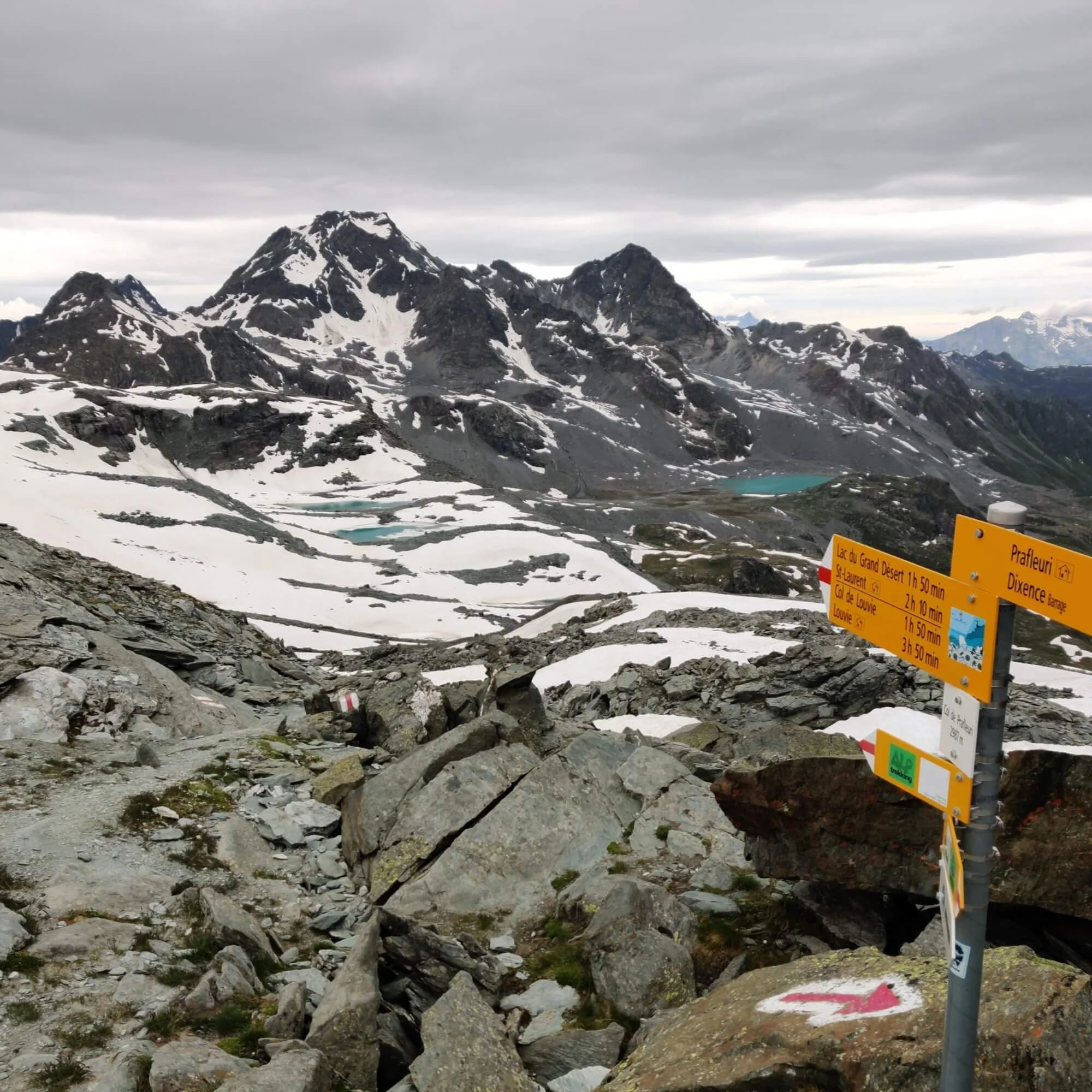
Day 7: Grand Desert on Walker’s Haute Route
Route Summary: I’ll leave the cabane early and descend to the small village of Fionnay in the Bagnes valley. The trail climbs steeply up to Cabane de Louvie through a protected wildlife reserve where Ibex are commonly seen. After an espresso break and chat with the guardian at Cabane de Louvie, I’ll go to the other end of the Lac before continuing the climb up to Col de Louvie, which has some impressive balcony trail sections and boulder crossings. The Grand Desert will be waiting on the other side, and I expect it to be covered in snow and tough going. After navigating a path through this alpine plateau to Col de Prafleuri, the descent will begin to Cabane de Prafleuri (which will not be open). I don’t plan to stay here long, as the lure of a warm shower will be enough to carry me the rest of the way to Hotel Grande Dixence.
Hikes following this trail: Walker’s Haute Route
Distance: 28.2 km / 17.5 mi
Elevation Gain: 1,964 m / 6,444 ft
Day 8: Grande Dixence to Arolla

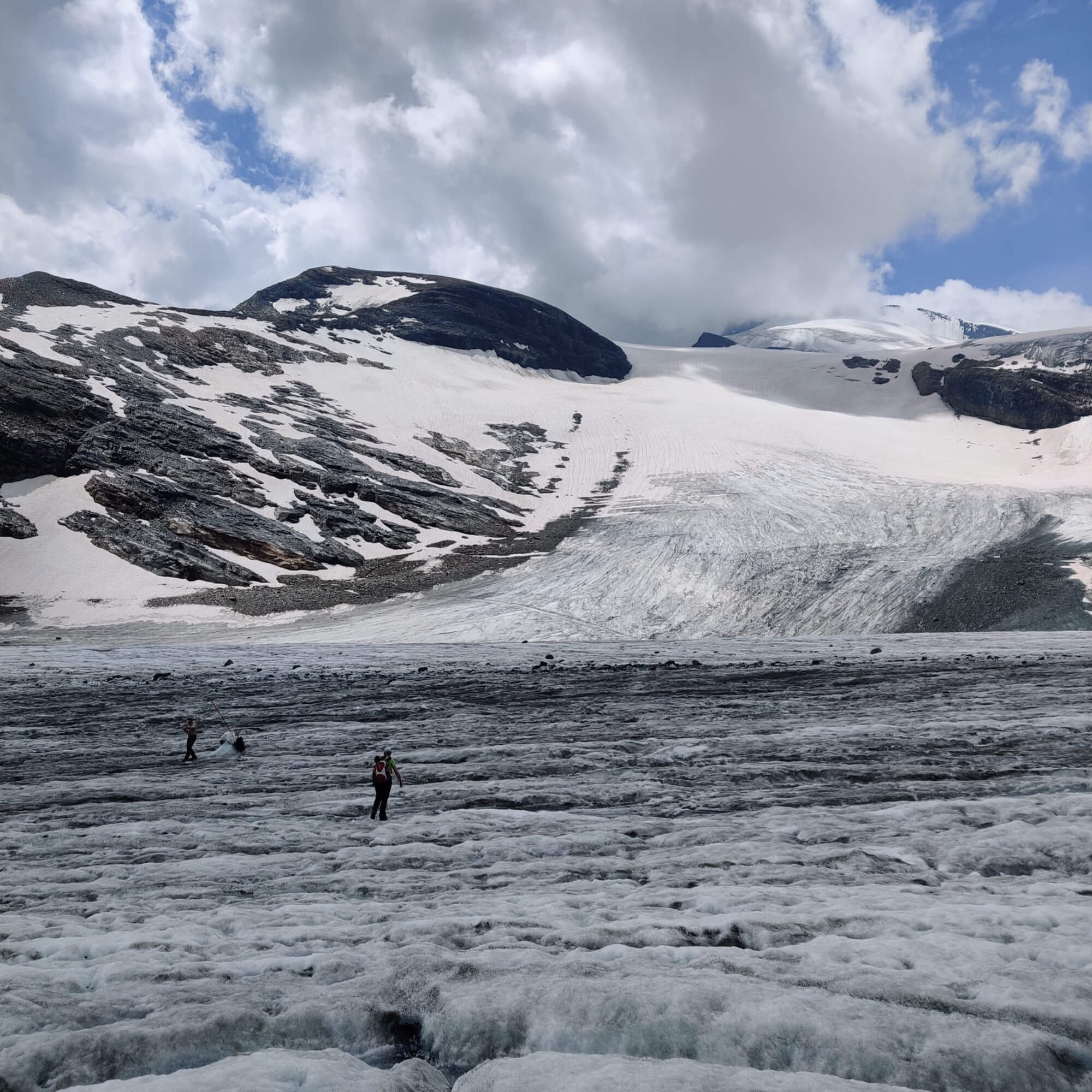
Day 8: Val Des Dix on Walker’s Haute Route
Route Summary: This is the shortest hiking day planned, and I’m sure it will be a welcome relief. The day starts with a steep ascent to the top of the Dam wall before following a track alongside the entire length. Once at the other end, I’ll climb deeper into Val Des Dix, taking the ridgeline trail to reach Cabane Des Dix (which I expect to be closed). I’ll continue on across the Cheilon glacier and up to Pas de Chevres, where the Matterhorn is visible on a clear day. Looking across at Tsijiore Glacier will be energising during the descent to Arolla, with views of Mont Collon being a worthy reward for reaching the village. Once I reach Arolla, I’ll begin a big public transport journey to Saas Fee, which will likely take five different buses/trains all afternoon :)
Hikes following this trail: Walker’s Haute Route
Distance: 20.2 km / 12.6 mi
Elevation Gain: 1,044 m / 3,425 ft
Day 9: Saas Fee to Grachen
Day 9: Glacier trail on Tour of Monte Rosa
Route Summary: Today, the route will cover the main highlights on the Tour of Monte Rosa trail on both sides of Saas Fee. I’ll catch the first bus from Saas Fee to Mattmark Dam, where I’ll begin hiking alongside the west side of Stausee Mattmark before climbing up to Schwarzbergschopf, which marks the south side of the Glacier trail. I’ll follow the markers to cross Allalingletscher and Hohlaubgletscher and reach Britannia Hutte for a break on the north side. Rather than hike down to Saas Fee, I’ll take the trail via Egginerjoch to the top Felskinn gondola station and catch it down the mountain. From Saas Fee, I’ll follow the thrilling höhenweg balcony trail all the way to Grachen, a cute village with carless streets and my finish location for today.
Hikes following this trail: Tour of Monte Rosa
Distance: 30.7 km / 19.1 mi
Elevation Gain: 2,199 m / 7,215 ft
Day 10: Grachen to Breuil-Cervinia

Day 10: Europaweg on Walker’s Haute Route and Tour of Monte Rosa
Route Summary: Starting with a bus and train ride to Herbriggen in the valley below, I’ll follow the new Europaweg trail up to the balcony and past Europahutte (it won’t be open yet). I’m not expecting the Charles Kuonen suspension bridge to be installed for the summer yet, so I’ll descend to Randa and catch the train into Zermatt for lunch on a patio with views of the mighty Matterhorn! The afternoon will start with a gondola ride up to Trocknersteg, where I’ll cross the glacier to Theodul pass, marking the border with Italy. Theodul pass is the highest elevation I’ll reach on this journey, and I’m sure I’ll take some time here to reflect on the experience. Today’s last section is a long downhill stretch to the Italian village of Breuil-Cervinia, which offers constant Cervino (Matterhorn) views and marks my finish line for this epic adventure!
Hikes following this trail: Walker’s Haute Route / Tour of Monte Rosa
Distance: 25.3 km / 15.7 mi
Elevation Gain: 1,707 m / 5,600 ft
What an adventure! While I am hopeful I’ll get to complete the entire route, it is dependent on the early season hiking conditions. Read about how I’m monitoring the snow depth/line in the preparation section below.
Preparation
I plan to start the hike at the end of May, which is in about 6 weeks, and at least 2 weeks before these trails are usually possible to hike. Given my early season start date, my preparation is focused on 3 areas
I’ll go into more detail below on what I’m doing for each area.
1. Fitness
I’ll level with you…I’m not in great shape at the moment.
I’ve been living at sea level and don’t have any mountains I can reach on a daily basis that have anything close to an alps elevation gain!
My baseline exercise is 10,000 steps a day which I achieve with a couple of short walks and a 6-7km / 4mi jog. This amounts to 3-4 hours of exercise a week, which I double every 2-3 weeks by doing a hike on the weekend.
To get in the best shape possible for this journey, I’ve decided to use a plan from Uphill Athlete, a mountain sports training group based in the Chamonix Valley. At a high level, the plan calls for an increase in my weekly exercise hours by doing;
3 x jog/hikes of 1 hour or more
1 x hill session
1-2 core/strength sessions
1 x long jog/hike of more than 3 hours
I’m making some adjustments to the standard plan so it’s organised into 2 x 3 weeks blocks and has a more gradual staged ramp-up to reduce the chance of training injury and ensure I’m starting my hike in the Alps off the back of a lighter training week.
I’ll be recording all my training into Strava - click here to follow along.
2. Conditions
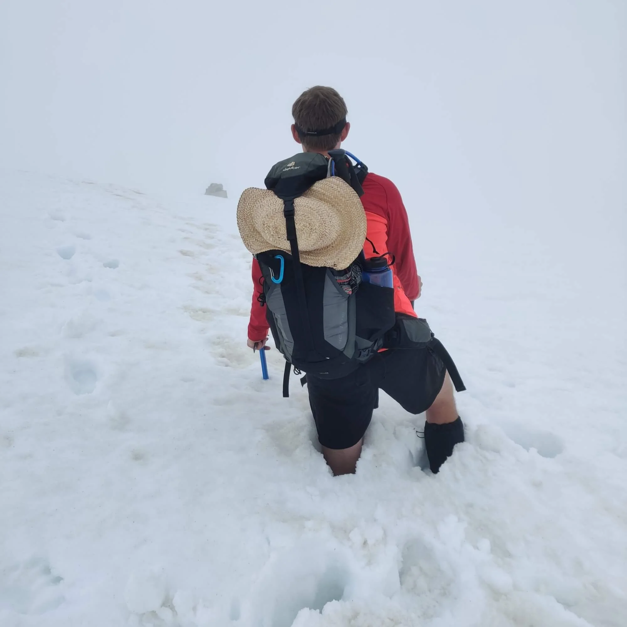
Early season hiking: Beginning of June on the Tour du Mont Blanc in 2019
The amount of winter snow still lying over the mid and upper mountain trails will be the main factor in whether I can complete my proposed route.
2017 was the last year with favorable early-season hiking conditions. I completed the entire Walker’s Haute Route during mid-June and only crossed snow in the Grand Desert and on the east-facing side of Augstbordpass. It has taken at least 2-3 weeks longer for the Walker’s Haute Route to be passable every year since.
I have a good feeling about 2022 though.
When I compare the current snow around Mont Blanc with this time last year, there is about 1-2 feet less depth at 2,500m / 8,200 ft which is a good sign for early season hiking.

This Year: 18th April 2022 (source: Meteo France)

Last Year: 22nd April 2022 (source: Meteo France)
Having said that, I’ve monitored early season hiking conditions in the Alps for enough years now to know that big dumps of snow can occur late in Spring and drastically impact plans.
So while I’m hoping and currently planning for the best, I’m expecting my route will need some adjustments in the week before I start and probably during the journey. For now, I will closely watch how the snow depth and line changes by predominately using the Meteo France Avalanche Bulletin for Chamonix Mont Blanc and the Swiss avalanche bulletin for Valais.
3. Plan flexibility
As I’ve noted above, starting this hike at the end of May is 2-6 weeks before it is usually possible to complete my proposed route. The main reasons it is not advised to start these trails any earlier than mid-June are;
The weather is less stable, with more rainy days on average compared to July/August/September.
There is winter snow still lying over the mid and upper mountain trails, which increases the risk of an incident and/or makes them impassable without mountaineering skills/equipment
Most mountain accommodation is still closed, making the distance between open options too much for most people to complete.
My experience on these trails does not make me immune to these factors. To manage these challenges, I’m planning to do the following;

Cervino: Italian side of the Matterhorn on the Tour of Monte Rosa
Make an overall update to my route in the week leading up to this journey, based on the latest snow/avalanche/weather reports and accommodation open/available.
Create one or more alternative routes/plans for each day that I can switch to if the conditions are too challenging and/or my progress is too slow.
While I’d love to complete my route in full, the reality of planning a journey through the Alps in early June means I have to be comfortable missing out on any section that trail conditions cause to be beyond my competency.
Goal of the hike

Wild encounters: Ibex on the Walker’s Haute Route
After each day, I’ll report on the conditions so it can become a starting record for the season that others can use when preparing for 5 trails I’ve noted at the top.
I last did an early season hike like this in 2019 (before COVID!), which triggered an avalanche of updates being provided and passed on by the community of hikers wanting to keep each other informed of the conditions.
In 2019, I managed all my communications on Instagram and WhatsApp. This year, I’m exploring whether there is a better way to facilitate community-powered updates that can keep self-guided hikers up to date and safe on the trails. I’ll share what I come up with in my next blog about this journey.

Author: Brendan Jones, Founder, The Hiking Club
A pizza-making, craft beer-loving, peanut butter connoisseur that has been exploring the great outdoors since completing the Duke of Edinburgh Award in high school. He started The Hiking Club to democratise hiking and the benefits that come from spending time in nature.